
 Image 1 of 4
 Image 2 of 4
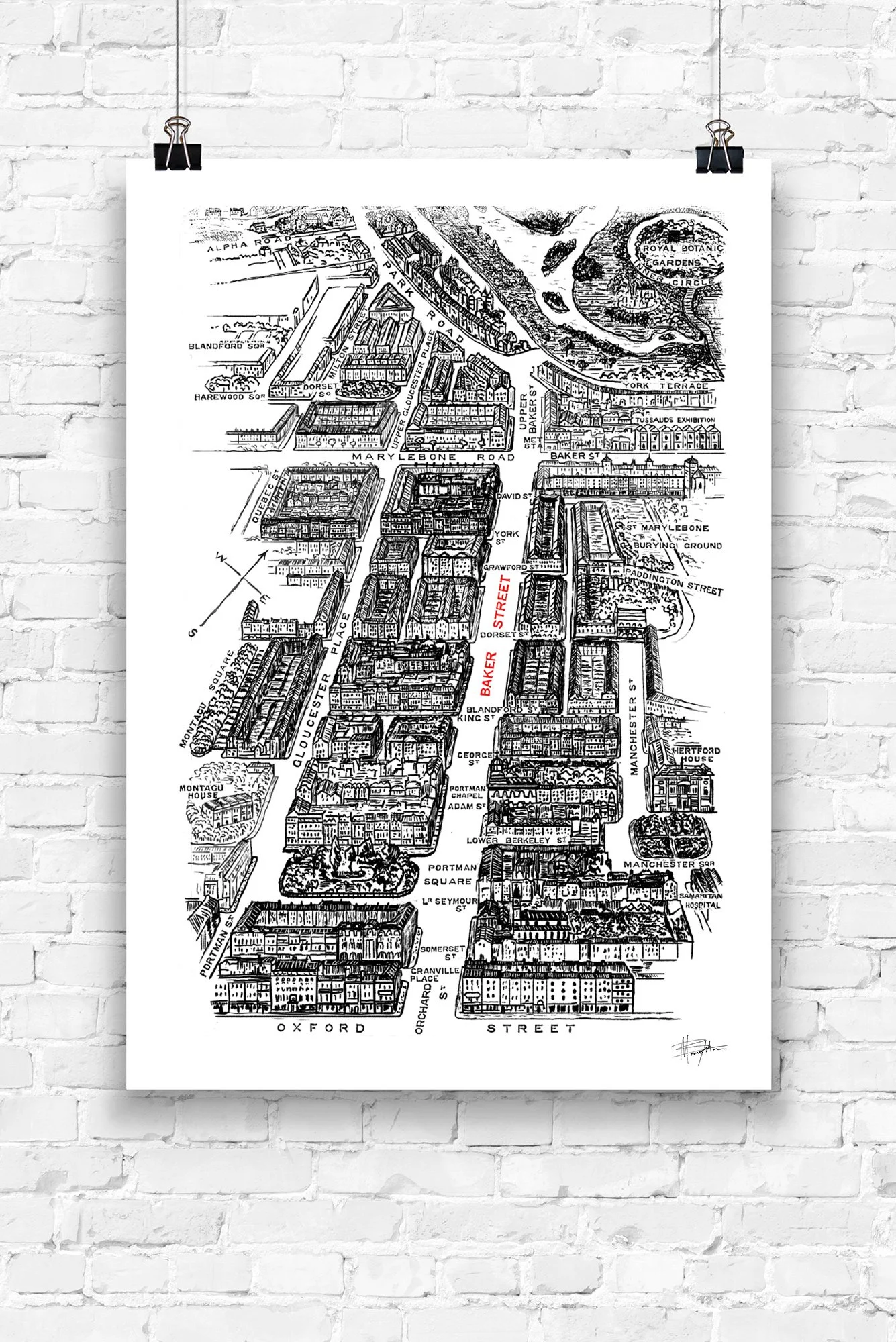 Image 3 of 4
 Image 4 of 4
The Story Behind the Cartography Illustration Immerse yourself in the atmospheric, gaslit alleyways of Victorian cartography with this limited-edition historical map illustration of 1880s London. This bespoke piece was born out of a major publishing commission by independent literary house Hipkiss Publishing, who invited me to conceptualise and execute a comprehensive series of interior artworks for a premium, collector's hardback reprint of Sir Arthur Conan Doyle’s debut novel, A Study in Scarlet.
The map charts the classic topography of the city as Sherlock Holmes and Dr John Watson would have navigated it, tracing the historic paths between Baker Street, Scotland Yard, and the dark corners of the late 19th-century metropolis. Rather than a dry historical record, this piece functions as an immersive literary artifact. As a professional book illustrator and graphic designer, my goal was to combine meticulous historical accuracy with a bold, contemporary line-art aesthetic. The result is a striking layout that speaks directly to Sherlockians, history buffs, map collectors, and lovers of classic British literature.
The Creative Philosophy & Printing Process My approach to map design and illustration focuses on balancing dense graphic texture with clean, modernist structures. I utilize variable line weights, intricate cross-hatching, and deep tonal contrasts to recreate the authentic texture and character of vintage copperplate or steel-engraved maps, whilst ensuring the final composition remains sleek and sophisticated for modern interior framing.
To preserve the absolute fidelity of the original hand-drawn elements, each limited-edition print is individually prepared using gallery-grade materials:
Premium Paper Stock: Somerset Museum Rag (300 gsm). This is a 100% cotton, heavyweight archival fine art paper with a beautifully smooth, matte surface. It is exceptionally durable to everyday handling and entirely free from artificial acids or chemical brighteners.
Giclée Printing Quality: Crafted as a professional-grade Giclée print utilising premium archival pigment inks. This specialized coating system guarantees an unparalleled colour gamut and exceptionally deep, rich blacks, ensuring the intricate cartographic lines remain crisp and lightfast for generations.
Studio Authenticity: Hand-signed and numbered by the artist. Every print is supplied with a signed Certificate of Authenticity documenting its exclusive limited-edition status, paper quality, and studio origins.
The map is elegantly proportioned on standard paper formats, creating a clean white margin that allows for immediate framing using off-the-shelf options or bespoke custom mounts:
A4 Format Option: Printed area measures 9 x 6 inches (228.6mm x 152.4mm) on a standard A4 sheet (210mm x 297mm).
A3 Format Option: Printed area measures 18 x 12 inches (457.2mm x 304.8mm) on a standard A3 sheet (297mm x 420mm).
Dispatch Time: Safely packed flat in heavy-duty, protective rigid materials and shipped from my Melbourne studio within 2–4 business days.
Australia & New Zealand: Carbon-neutral standard shipping is completely included in the total cost.
International Worldwide Delivery: An additional flat rate of AU$10 will be applied at checkout for tracked international shipping.
Combined Shipping: Purchasing more than one illustration print from the studio? An extra AU$4 is automatically added for combined packaging at checkout.
The Story Behind the Cartography Illustration Immerse yourself in the atmospheric, gaslit alleyways of Victorian cartography with this limited-edition historical map illustration of 1880s London. This bespoke piece was born out of a major publishing commission by independent literary house Hipkiss Publishing, who invited me to conceptualise and execute a comprehensive series of interior artworks for a premium, collector's hardback reprint of Sir Arthur Conan Doyle’s debut novel, A Study in Scarlet.
The map charts the classic topography of the city as Sherlock Holmes and Dr John Watson would have navigated it, tracing the historic paths between Baker Street, Scotland Yard, and the dark corners of the late 19th-century metropolis. Rather than a dry historical record, this piece functions as an immersive literary artifact. As a professional book illustrator and graphic designer, my goal was to combine meticulous historical accuracy with a bold, contemporary line-art aesthetic. The result is a striking layout that speaks directly to Sherlockians, history buffs, map collectors, and lovers of classic British literature.
The Creative Philosophy & Printing Process My approach to map design and illustration focuses on balancing dense graphic texture with clean, modernist structures. I utilize variable line weights, intricate cross-hatching, and deep tonal contrasts to recreate the authentic texture and character of vintage copperplate or steel-engraved maps, whilst ensuring the final composition remains sleek and sophisticated for modern interior framing.
To preserve the absolute fidelity of the original hand-drawn elements, each limited-edition print is individually prepared using gallery-grade materials:
Premium Paper Stock: Somerset Museum Rag (300 gsm). This is a 100% cotton, heavyweight archival fine art paper with a beautifully smooth, matte surface. It is exceptionally durable to everyday handling and entirely free from artificial acids or chemical brighteners.
Giclée Printing Quality: Crafted as a professional-grade Giclée print utilising premium archival pigment inks. This specialized coating system guarantees an unparalleled colour gamut and exceptionally deep, rich blacks, ensuring the intricate cartographic lines remain crisp and lightfast for generations.
Studio Authenticity: Hand-signed and numbered by the artist. Every print is supplied with a signed Certificate of Authenticity documenting its exclusive limited-edition status, paper quality, and studio origins.
The map is elegantly proportioned on standard paper formats, creating a clean white margin that allows for immediate framing using off-the-shelf options or bespoke custom mounts:
A4 Format Option: Printed area measures 9 x 6 inches (228.6mm x 152.4mm) on a standard A4 sheet (210mm x 297mm).
A3 Format Option: Printed area measures 18 x 12 inches (457.2mm x 304.8mm) on a standard A3 sheet (297mm x 420mm).
Dispatch Time: Safely packed flat in heavy-duty, protective rigid materials and shipped from my Melbourne studio within 2–4 business days.
Australia & New Zealand: Carbon-neutral standard shipping is completely included in the total cost.
International Worldwide Delivery: An additional flat rate of AU$10 will be applied at checkout for tracked international shipping.
Combined Shipping: Purchasing more than one illustration print from the studio? An extra AU$4 is automatically added for combined packaging at checkout.